Saturday, April 25, 2015

Taroko National Park (太魯閣國家公園) Day 2


Click here for Day One at Taroko National Park.

Day Two:

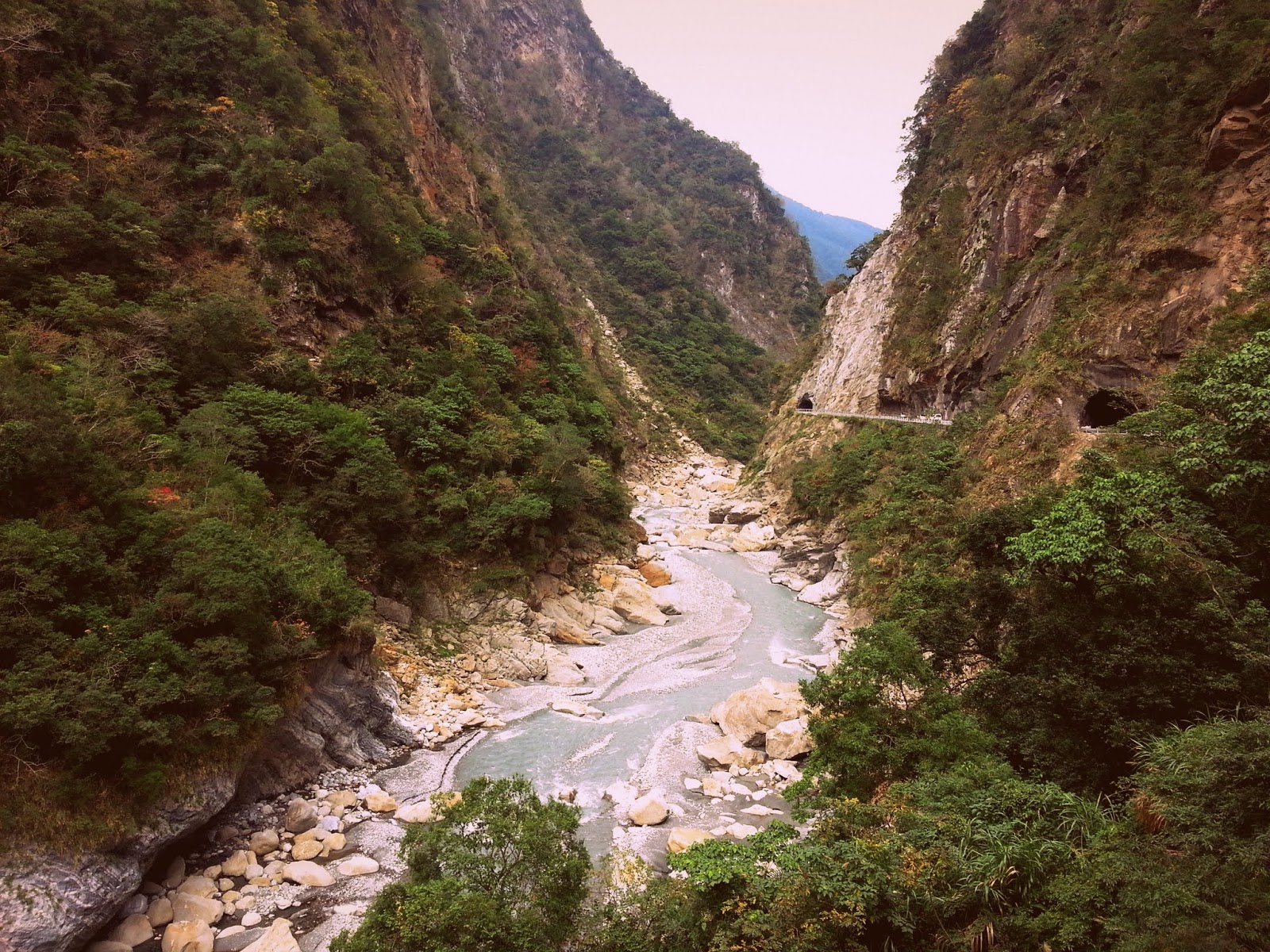
We started the day back at the entrance of the park, first stopping at the tourist center (national parks in Taiwan have wonderful tourist centers with friendly, informative staff, clean restrooms, and free water refill machines). First up for the day was Shakadang Trail. Unfortunely we soon realized that this is also the first trail of the day for the tour buses (why they all seem to travel together, I don't know... maybe so as not to punish the other visitors), so the start of the trail was packed with people taking selfies. It's a 4.5km trail cut into a mountain and following a river - a level, easy path leading to 3D Cabin... except that it was closed about a kilometer and a half in! Neither the park's website, maps, visitor center, or even the trailhead mentioned this!!! Unfortunately there were a few makeshift stands selling sausages and jewelry causing people to linger in the area, otherwise we would have crossed the barricade and seen how far we could go. (Signs noting fines and hotlines to call if you saw people crossing were what made us care that people would see us.)


cut into the mountain, Shakadang Trail

the relatively easy but pleasant Shakadang Trail

trail closed ahead, Shakadang Trail

Continuing on, we drove our motor scooter back up the gorge's road passing many of the places we visited yesterday and headed to Lushui Trail, which is a short trail overlooking the the road as well as the Liwu River below. There are more tunnels, so again a flashlight is extremely useful. (This time actually I remembered my headlamp, as yesterday we had to use our phones for light.) Being so close to the road there is surprisingly nice landscape and we did mange to see one wild monkey hanging out in a tree staring at us. It's a level, 2km walk. There are also numerous signs warning of falling rocks, and if you don't believe the signs, there are more than enough fallen rocks on the trail and dented fence bars to given them merit.


Beware of Rockfalls, Lushui Trail

Lushui Trail

view of Liwu River from Lushui Trail

Still having time left in the day because Shakadang Trail was closed, we headed further up the road to check out Lianhua Pond Trail. This wasn't on our itinerary but it turned out to be more than worthwhile, if not one of the more scary trails I've ever done. The trail to the village beyond (Meiyuan Zhucun agricultural road) was closed due to landslide damage(?), but the detour to the pond was still open. [I believe they are both open now.] The trail is high above the river and the sheer straight drop down is vertigo inducing. The first suspension bridge is insanely high and about two-thirds of the way across we realized that at one point it broke (or was about to break) and has since been haphazardly fixed with a mixture of wooden planks and plastic plumbing pipes. I usually don't mind heights but crossing that makeshift fix-up was mentally difficult. I've crossed a lot of suspension bridges in this country but this was the highest and the only one I've actually felt afraid on.


seriously damaged with scary sheer straight drops down, Lianhua Pond Trail

the last third of it improvised, Jiumei Suspension Bridge

and then we realized the bridge was broken, Jiumei Suspension Bridge

After the deathly-high suspension bridge we crossed a number of landslide areas that tested our guts, and should be avoided by most people. The trail has been wiped out in two or three places (I'm forgetting now), but people still continue to cross. One false move or slip of the foot and we would have slide down to our deaths. I felt like the worst part was knowing that every tricky pass we did had to be retraced to get back to our motor scooter on the main road. All the tourists we saw at the beginning of the day were nowhere to be seen. We only saw two other Taiwanese couples hiking here. There was also an older man, who effortlessly crossed one of the landslide-destroyed bits (he had plastic toys poking out from his backpack and was likely a villager heading home along the closed path beyond).

To add to the tension, there were numerous rocks (ranging from small rocks to large boulders on the path that had clearly fallen from above. Neither of us had brought our scooter helmets this time, and though we joked about wearing them yesterday, today they were looking potentially useful. However, we could also see massive dents on the bars along the path's edge that implied helmets wouldn't do squat to save us if the right rock decided to fall. It was a thriller of a trail, but I admit that both my friend and I felt seriously uneasy.

After we crossed the second bridge and began the ascent up to the pond, it started to drizzle. We still had to return back across those landslide areas and if the trail became wet, we worried that they would become impassable. So we debated for awhile about whether to return or continue on, hoping the rain wouldn't worsen. Guessing that the pond would be underwhelming and that we had already seen what this ascent had to offer in terms of scenery, we eventually turned around and started heading back. Actually, crossing those scary parts was a lot easier the second time around, and I felt a bit foolish for being so scared the first time. Also, I insisted on going first this time, as I think watching my somewhat clumsy friend cross them had freaked me out more than if I had just done them without seeing him first.


dented and missing barricades due to falling rocks, Lianhua Pond Trail

the much safer, second bridge, Jiumei Bridge

We reached our motor scooter safely, and decided to head further up the road, which my friend had driven before years ago when crossing the island by motorcycle. It was still drizzling, but not enough to warrant us heading back just yet. As the road continues on, the elevation continues upward and the weather gets colder and colder. Soon we were in either a deep fog or the clouds, in this weather it was hard to tell one from the other. At this point I was hugging my friend tightly for both warmth and protection against the increasing hard, cold pellets of rain. We continued driving for maybe forty-five minutes, not reaching as high as he wanted to show me, but it was so foggy that there wasn't much of a view, not to mention that I couldn't see anything through my helmet's rain-and-fogged-out visor. Plus, I was shivering uncontrollably with cold.

Not long after we had turned around we heard a loud thump on the road behind us. I didn't feel safe enough to turn around, but I immediately knew it was a falling rock hitting the road. My friend caught a glimpse of it in the scooter's mirror, and rather skittishly said that that was not something he wanted to see. I didn't inquire further, and neither of us were interested in turning around to check it out. Freezing, wet, and uncomfortable, we were both very ready to leave.

As we descended back down the rain slowed until it finally stopped, and the temperature became bearable again. We passed all the trails we had done in the past two days, as well as all the parked tour buses in front of Eternal Spring Shine, right on time for whatever there is or isn't to see in the early evening / late afternoon. After we passed through the main entrance to the national park, we stopped at 7-Eleven to rest and warm up with some soup and hot chocolate. Since it wasn't raining anymore, my friend let me drive the hour back to the hostel (I don't have a license and this was only my second time riding a scooter in traffic... Taiwan traffic at that). I managed not to kill us, though I had trouble keeping the scooter balanced when stopping at a couple of the stoplights. I blame my friend's weight for throwing off me off, and not my mad scooter skills.


For more information visit Taroko National Park's very informative website.
*** Check their website for trail opening and closures as they often change. ***

Two days is more than enough time to explore Taroko Gorge's basic offerings, though there are a couple amazing trails that require permits in advance, but those are better saved for special trips out and not first-time visits. River tracing is also popular during certain seasons.

Taroko National Park (太魯閣國家公園) Day 1


Cimu Bridge

Two years into living in Taipei I finally went to visit Taiwan's most famous geological wonder, Taroko Gorge (太魯閣). With peaks as high as 3,000 meters, this long, narrow gorge is a popular destination for local Taiwanese and Mainland Chinese alike. However the thought of visiting on a crowded weekend with tour buses shooting up and down the Central Cross-Island Highway, which runs through the gorge, was enough to keep me delaying my visit. But through a last minute argument on what to do for the weekend, I managed to score train tickets on a Thursday night for the upcoming weekend (it's definitely better to get tickets much further in advance as weekend trains from Taipei to Hualien usually sell out).

We took an early Saturday morning train from Taipei Main Station, arriving in Hualien (花蓮) around two hours later. The street just outside the train station is lined with scooter rental shops and we asked about the prices at a couple while we made our way to Formosa Backpackers Hostel, which I had booked in advanced. The hostel seemed to be recently renovated with freshly painted walls and a mixture of traditional Taiwanese furnishings and new Ikea furnishings making up the more hostel-related stuff (bedding, lamps, etc.). For an added bit of warmth for a bookworm, they had a large library on the first floor, as well as numerous other books spread about the hostel's various floors and rooms in Chinese, English, and other languages. Our double-bed room was simple and comfortable, and the shared bathroom was clean.

The girl who runs the place keeps watch at the bar downstairs, speaks English well and is helpful with any questions. We rented a scooter through them since it was the same price as the places by the train station, and after filling out the paperwork we waited for it to be dropped off (another perk).

The drive from Hualien to the gorge is about an hour. I definitely recommend renting a scooter over using the buses, since the gorge consists of a long road (one could ride for hours) with scenic spots and short trails dispersed along the way. Walking between these places is not possible and waiting for buses, which didn't seem to run very often at all, would be a hassle. Most people seem to visit the gorge in tour bus groups with their flag waving, mic carrying guides, which I would never recommend. (These groups were also older people and always Chinese-speaking, so not really an option for foreigners anyway.) We also went in January, which in retrospect was off season and a good choice. The hostel was cheaper and the gorge was wonderfully void of the traffic and masses I was anticipating. The only issue is it gets surprisingly cold the further up you go, especially on a scooter, so dress accordingly.


Trail Map
Map of Taroko National Park

Day One:

We started at the much photographed Eternal Spring Shrine. The shrine itself is quite small and is more remarkable from a distance against the backdrop for the gorges' massive walls than to walk through. DO NOT come here around 4p.m. as this is when ALL the tourist buses stop here. (For sunset? I don't know, because it was so overcast we never saw the sun, and the walls of the gorge don't really make that sound reasonable.) Being relatively close to the mouth of the gorge and the park's entrance they create a huge traffic jam, though with a scooter you can weave between the cars and buses to manage a reasonable escape.


(Changchun) Eternal Spring Shrine

Next we drove to Swallow Grotto, named for the birds that make their homes in the rock walls. We parked our scooter and walked the short walkway along the road. We kept our helmets on in case of falling rocks (actually more to keep in fashion with the other walkers than for actual fear of falling rocks, not that helmets aren't recommended).


Yanzikou (Swallow Grotto)

Yanzikou (Swallow Grotto)

We tried to visit the Tunnel of Nine Turns (Jiuqudong) next but it was under construction at the time, so we made our way to Tianxiang, which turned out to be an uneventful parking lot with a few small restaurants and souvenir shops. It mostly attracts people for the nearby picturesque Xingde Temple, which rests higher up the mountain. There's a trail up to reach the temple, but we decided to admire it from below, preferring to make our way to the next place since we were a little worried about both time and weather.


Xiangde Temple

Not too far from Tianxiang is the delightful Baiyang Trail. BRING A FLASHLIGHT and come prepared to get wet. The start of the trail is through a 380m, slightly leaky, pitch dark, cement tunnel. Navigating the darkness is both slightly eerie and slightly exciting. After the tunnel, the trail follows along the side of a mountain, looking down to the river below. There are a few more rock tunnels until you come to an open area to the left, and the way to Water Curtain Cave on your right (everything is well sign posted).


Baiyang Trail

entrance to the second tunnel, Baiyang Trail

more caves and tunnels, Baiyang Trail

view of the trail from a lookout point, Baiyang Trail

Water Curtain Cave is completely dark with spring water from the roof of the cave continuously leaking down (also threatening the cave to eventually collapse). Bring a cheap 7-Eleven poncho (or use one of the abandoned ones at the entrance to the cave, as we did) and/or an umbrella. Most of the cave floor is too rocky and deep in water to safely traverse in the dark, but there is a narrow path along one edge just wide enough for one person. It's a really magnificent, otherworldly, and slightly scary walk through the tunnel and on to the other side. There's a second cave after that but it's closed off to visitors because it's too dangerous (of course I tried to enter it anyway, and yes, it actually is too dangerous). Round trip, the trail is about 4km long.


Water Curtain Cave, Baiyan Trail

Winter days being shorter, we started to make our way back to Hualien. There's a popular night market in the city but we skipped it, my friend loathing night markets and me having had more than my fill in this country (really, they're all the same, only some more local, while others more touristy in goods). Instead we asked at the hostel and found a nice vegetarian restaurant just up the road called Greenland (143 JianGuo Road).

Click here for Day Two at Taroko National Park.

For more information visit Taroko National Park's very informative website.


Saturday, April 18, 2015

Camping in Maolin (茂林), Duona (多納), Baolai (寶來)


Continuing our trip in Maolin County (for part one click here), we decided (for no particular reason beyond it getting dark) to camp in the valley of the town between Maolin (茂林) and Duona (多納). We had been trying to find a place my friend found years ago when he was here last but were unsuccessful. Not having much camping experience I still struggle to fall asleep to the sounds of fighting dogs and fornicating cats.


This island is small and trains are convenient, but wow, having a rental car is easy to get used to

Camping at the sight of a memorial probably wasn't the politest of things to do

In the morning we took one last stroll around Duona, a small town at the end of the valley's road, known for its aboriginal culture. The valley's riverbed is cluttered with slate which they seem to collect and sell. There are some short trails and murals, but mostly, as with much of Taiwan, it's all about the food. There doesn't seem to be much of an economy in the town, so nearly every home on the main road has a few tables and a restaurant mainly serving barbecued meats and my favorites: sticky rice steamed inside columns of bamboo and purple rice wrapped in banana leaves. I had a delicious all-carb rice lunch while my friend went for the barbecue (烤肉).

Before the devastating Typhoon Morakot hit in 2005, Duona was using their access to hot spring water to develop a tourist economy, but the typhoon washed away and closed off their pools. Abandoned hotels and hot spring areas can been seen here and there along the edges of town that we drove through.


Duona, a small, village with strong aboriginal history

Duona's famous slate houses

just passed Duona after the road ends, the river valley seems to go on for quite some distance

Remnants of Typhoon Morakot damage, Duona's hot springs used to be nearby

Since the makeshift natural hot spring pool my friend found a few years ago was now gone (replaced by a 70% finished small building with a hot spring pool and lockers, but no running hot spring water), we decided to head an hour's drive north to Baolai (寶來), a town know for its hot spring water. We went straight to their tourist center but had trouble deciphering if any of the hotels had public pools versus paying for a room (both our Mandarin skills are so-so). We got some recommendations and checked out a few but none of them had public pools. There is one older place that might have but reviews concerning cleanliness on Google weren't that polite. On our last trip I got pink eye from a less than clean hot spring pool in Dongpu (東埔), so I wasn't too keen on trying this one.

So seeing as in a few days my friend was leaving the country indefinitely, we decided to splurge and rent a fancy (by our usual standards) hot spring hotel room. Rooms are rented either for the night or for ninety minute sessions. I felt a little rushed knowing there was a time limit, but the place wasn't busy and they didn't seem to care that we returned the key fifteen minutes late. I can't remember the price, but it was somewhere around 1,000NT. The room had two hot spring pools (one with water jets), shower, a balcony, and a bed with a wall-mounted TV. I still prefer wild outdoor hot springs like Bayan (八煙野溪溫泉) in Yangmingshan (陽明山), but this was still really nice for a change, if not a bit kitsch in decor and amenities (British-style tea cups, individually wrapped Q-tips, personal lubricants, etc., etc.).


A hot spring hotel - Grand Orchid Villa (國蘭花園溫泉會館), Baolai (寶來)

My first hot spring hotel room

For more photos from this trip, click here.

Maolin National Scenic Area (茂林國家風景區)


Maolin (茂林)

If you have your own transportation, about two hours west of Tainan (台南) is Maolin (茂林) District, part of Kaosiung City (though why this distant rural area is part of the Kaoshiung "city" and not "county" makes no sense to me). Between November and March (February being the peak), the Taiwanese Purple Crow Butterfly's winter migration crosses through the Maolin Valley giving visitors the chance to view hundreds of thousands of these butterflies in one of only two winter butterfly migrations in the world (the other in Mexico). (For more information check out their website.) The best time of day to see butterflies is in the morning, after the sun has come up enough to dry the dew off their wings so they can fly. The gentle Zishalishali Trail ( 姿沙里沙里步道) is the main trail to see butterflies and is not far off from the main road's entrance into town (and being the town's main attraction, you won't have trouble finding signs leading to it).

The trail is well constructed (begging for tourists), and we saw about a dozen butterflies on it, BUT after climbing up and reaching the sign pictured below, if you turn left instead of right you'll end up walking down a wide dirt road and it was there that we saw THOUSANDS of butterflies. A man driving a large truck nearly charged and ran us over as stood there in awe. He informed us we should have come in February to see even more (we were there March 2nd). From the sign post pictured below you can also go left and up another trail, which leads to the uneventful Maya Pavilion but there is a nice view of the valley from there, see the picture below.) We took the "foot path for admiring butterflies" for a nice walk that leads back into town.

Zishalishali Trail ( 姿沙里沙里步道)

Zishalishali Trail ( 姿沙里沙里步道)

Spiders also seem to enjoy the Purple Crown Butterflies

We actually saved this butterfly from a spider web and here it rested trying to clean the cobwebs of its wings

View from Zishalishali Trail of the road leading into Maolin
The road in the picture above is fairly new. It replaces the one that ran along the mountain and was (likely) destroyed by Typhoon Morakot (you can still see parts of it that weren't washed away by landslides). Having traveled more now through central Taiwan I see that they've learned to build raised roads through the valleys rather than along the mountains. Most of the time the country looks so peaceful, but in rural areas there are remnants of previous disasters (typhoons, floods, earthquakes, and landslides) all over as a reminder that any day can turn to a bad day here.

After seeing the butterflies we drove further into the valley to see Maolin National Scenic Area's famous meander cores (hills formed by curving stream waters... I had to look that up during the trip), waterfalls, and gorges. Since Taiwan is experiencing one of its worst droughts this year, we only went to one of the waterfalls and I won't even bother posting a photo of its dripping.


Duona Bridge (多納大橋)

Dragon Head Mountain (龍頭山) - this meander core looks like a sleeping dragon from this angle

an easy and short ridge to Duona Suspension Bridge

Duona Suspension Bridge (多納高吊橋) - rebuilt, but originally built by the time of  the Japanese
occupation and subjugation of the aboriginals

Serpent Head Mountain (蛇頭山) - another meander core, this one looks like a resting snake

For part two, our visit to Duona Village and Baolai for a hot spring, click here.
For more photo from this trip, click here.


Making pineapple cakes, Battleship Rock Trail, and Beitou Hot Spring

Earlier this week my Mandarin language class went on a field trip to Kuo Yuan Ye (郭元益), renowned (if not touristy) for making traditional Taiwanese pastries. There we made pineapple cakes (鳳梨酥), Taiwan's most famous tourist commodity and a common gift given to people as a souvenir. (I know I've given away a lot of them.) These deliciously dense, chewy, bite-sized cakes are traditionally filled with pineapple preserve but numerous variations exist. I've likely tried a dozen different famous brands, with Chia Te and Sunny Hills probably being the most famous (I prefer the latter).

They were fun and simple enough to make, mixing sugar, butter, eggs, and flour together to make a dough that was then flattened and wrapped around of dense cube of pineapple goodness. They are usually marked with elaborate Chinese characters (saying what, I don't know, maybe just that company's stamp). For ease, most of my classmates just put their initial to distinguish theirs from the rest, while I tried writing my Chinese surname on one, putting disgruntled faces on the rest (bottom right corner of the baking sheet). They came out pretty good though far from the best I've ever had. And of course we had to individually wrap and package each cake, box them, wrap the box, and bag it, because all gifted foods are extravagantly packaged in eco- unfriendly, single servings. (It bothers me more getting a box of cookies, anywhere from five to fifty-plus, all individually wrapped, though having to unwrap each cookie does impede binge eating.)


Making pineapple cakes - before and after being baked

Since Kuo Yuan Ye is near Shilin (士林) Station, I took advantage of being up north on the MRT's red line to do a short hike that I had been putting off (too short of a trail to want to use up a day on the weekend but too far off from where I live to do on a shorter work day). The trail starts inside the architecturally unremarkable Yang Ming University (國立陽明大學) near Shipai (石牌) Station, gently climbing up steps to give excellent views of northern Taipei.


The first part of the trail is gentle upward stairs

Taipei is most always hazy but the view is still worthwhile

View further north toward Tamsui and Yangmingshan National Park

Within less than an hour's walk from the MRT station, I reached the trail's eponymous Battleship Rock (軍艦岩), a large area of bare, smooth rock surface at the peak, commanding excellent views. I didn't have the patience to wait for some women to finish their one-hundred-and-one selfies to actually summit the rock peak itself, but it was still a large enough area to enjoy.

Further down is a small, typical recreation area with its plastic stools, foam puzzle-piece flooring, and sun-bleached canopies, as well as some typical mountain-side exercise equipment (half-buried tires for back bends, bars for stretching and pull-ups, dusty hula hoops, etc.). I enjoy seeing these places because I find them very Taiwanese, also appreciating the strong sense of community and activity that elderly people have here.


Battleship Rock (軍艦岩)

A nearby community's recreation area

After another thirty minutes or so of gentle hiking, I arrived at Lovers' Temple (情人廟), a small but peculiar temple (in the sense that it doesn't look like other temples in Taiwan) seemingly in the middle of nowhere. Except for one nun wearing headphones while sweeping the bathroom area, I didn't see a single other soul. (I wondered what she could be listening to, Buddhist chants or Bruno Mars?)


 Lovers' Temple (情人廟)

 Lovers' Temple (情人廟)

 Lovers' Temple (情人廟)

 Lovers' Temple (情人廟)

 Lovers' Temple (情人廟)

After the temple the trail continues toward Beitou (北投), an area famous for its hot springs. Before arriving though, I came upon a strange, massive rock that appeared to be the site of an abandoned temple or worshiping area. Windows were carved(?) into two of the rocks to make small offering areas. There were ropes to climb up the one rock, but it didn't look like the top would yield much of a view. After trying to hoist my short legs up the first bit I decided not to bother and continued on, walking through an abandoned housing area (gates that no longer lead to residences, cracked window glass revealing long abandoned hot spring pools, etc.) before reaching Beitou proper.


A window with candles and offerings

Outskirts of Beitou
Arriving in Beitou, I went to visit Thermal Valley first, a large depression formed by a volcanic eruption, steaming with 90°C (194°F), sulfur-smelling hot spring water. After enjoying Taiwan's hot spring culture for two years now, the smell of sulfur triggers in me a desire to take off my clothes and soak in a bath with old people.

I continued on to Beitou's outdoor public hot spring. For a mere 40NT (about 1.30US), I can soak in three different hot spring pools, ranging from hot (38°C) to slightly uncomfortable (41°C) to oh-my-god-it's-cooking-my-insides (45°C). There are also two cold pools, that can knock the wind out of you, but are especially great in the summer. Everyone has their own routines, and I especially enjoy the people watching at public hot springs like this one. Men in their 70s will soak in the hottest pool, their skin turned a deep red color from the heat, and then drop down and do a series of push-ups. Elderly ladies will huddle in the corner of the medium heat pool with small towels on their heads, chatting and gossiping. I usually soak in the middle pool for ten minutes, then the cold pool for five minutes, then the hot pool, then the cold pool, etc. Make sure you drink lots of water, as it's easy to get light-headed from the heat. There are changing/shower stalls, and make sure you shower (or at least rinse) in one before entering the pools (for sanitary reasons). If you don't a guard will blow his whistle and gesture you to do so (there are signs posting hot spring etiquette with English, but also if you don't know what do to, just watch what everyone else is doing). There are also lockers for 10NT, which I used the first time I came here, but it's Taiwan, so they're really unnecessary as no one would think to steal your things.

From the hot spring it's a short walk to Xinbeitou MRT Station and back home.


Hell's Valley (地熱谷)

Beitou Public Outdoor Hot Spring... I'm going to miss this place a lot

For more photos of this trip, click here.